Featured Post

Legends of the Turnbull Canyon areas in Whittier and Hacienda Heights, CA.

Turnbull Canyon After living near Turnbull Canyon now for about a year, and having passed through the canyon many times even before movin...

Tuesday, August 6, 2013

Bosque Del Rio Hondo, Rosemead, CA.

Bosque Del Rio Hondo

(Blog In Progress)
Just down the street from Whittier Narrows and Legg Lake you will find an old swimming hole referred to as "Pig Beach". A place for people who couldn't make it down to the beach. 


Area is mostly dry brush, that is normally what you come across in this area. However, closer to the river and the creek nearby there are plenty of trees and green shrubs.


I love this picture below, its as if the world if tilting left!


This is the bike trail that runs through the area.


Walking off the trail a bit we found some shade.


Right along side the bike path is a series of power/phone lines. We came through this open area and found a pile of what appeared to be white PVC pipes. Not sure if we entered a restricted area as no signs where posted to stay out and there were no enclosures. A sad pile of pollution!


Several signs are posted further along the trail, they are all covered with tagging. It appears to say that the water is polluted, not to swim as it can make you ill. This is understandable as the Los Angeles River drains in to this area. But I found many accounts online of people swimming here.


The seasonal river runs under this bridge, the street above is San Gabriel Blvd.


1 sad lonely bench.


Looking back towards the entrance. Under the bridge there is a small creek, that does have water running through it.

Parking area, there are benches, restrooms and an open park like area.


Entrance to the parking area.


Wednesday, July 10, 2013

Arroyo Pescadero Park, Whittier, CA


Arroyo Pescadero Park and Deer Loop Trail

This trail located off of Colima Rd. just a bit north of Marvista Rd, started off with a paved fire road as the trail. About half a mile in the trail finally turns into dirt. We went along the trail heading south which loops around and then heads north and south again finally ending up at the deer loop trail (which is in the lower left half of the map below). Throughout the trip to the deer loop trail houses from the neighborhood to the south were visible. So this is literally right in some peoples back yard. The trail was wide and seemed easy to travel on for the kids. Once onto the Deer Loop Trail we came across a way to wonder off the path and take some pictures of some strange old debris piles and a 10 foot canyon filled with concrete debris. 

This area is just a bit to the east of the Turnbull Canyon hiking area. After researching the area further online I discovered that the land was gifted by an oil company to either the city or the county, and is now under scrutiny because further drilling is being requested and we did come across a section that was prohibited to enter by the public, there were oil rigs and miscellaneous equipment beyond that barrier.


This is the Deer loop trail looking south, off to the left was a field of dried grass and a ravine, and to the right a ton of brush. We spotted a few rabbits in this area and heard a lot of noise in the brush near the ravine to the right, it could have been anything but it sounded pretty large. We love to listen to our surroundings when we go hiking, always hoping for a deer or something special to cross our path in our beautful Whittier Hills.


And here is a picture looking north on the trail to where we came in from. We had walked through the dry grass on the right side of this photo below and they got prickly stuff in their shoes and had to take a break to de-prickle their socks!


Here is that ditch / small canyon filled with debris I mentioned earlier. Its off the trail so not really an eye sore if you plan to stay on the trail itself.


 Another angle of the debris filled ditch.


And another.
 One last one.

 There is a house across the way in the background there. Just included it for the heck of it :-)


There were additional trails further west on the deer loop trail that we did not explore yet, we seen many people coming from that direction all in workout clothes and running shoes. So from visual assumptions it appears to be a good area to jog. And once again watch for poo (or scat as my 11 year old calls it). Get out there and enjoy...


Murphy Ranch Park. Whittier, CA


Murphy Ranch Park Trail

Located just a few blocks east of La Serna High School at 16200 Las Cumbres Drive. Whittier, CA. Just a bit east of the Turnbull Canyon hiking area. The kids and I enjoyed this park, right from the start there are plenty of benches to picnic before your hike. And for some reason they are housing a whole flock of goats as shown in the photo below. Dogs and horses are welcome as well.


The kids got a kick out of the goats even though the goats did not share in the same amusement with my children, in fact the goats looked like they could not care less we were there. LOL


OK so moving on to the hike. We took the center wide trail which just looped around up into the hills at the end to the right and came back down to the beginning. The loop is an incline and has a slight zip-zag to it to reduce the rough incline. According to the trail map there are a few other trails off to the left from the beginning, that may be a better choice for a view of any sort? Not sure yet. 

We did venture off the main trail at one point to the left down into the dried up stream bed. The stream bed got narrower as we went along and we had to jump from side to side of the stream as it drops off at certain points with no where to walk. It was a bit difficult to find a way back up out of the stream, so unless you are ready to climb or turn back around I would just avoid the stream bed, its deep with high canyon walls on both sides for the most part. 

It appears that if you choose the other trail to the left (of the main trail) from the beginning, you may have a view of the stream bed from above. Ill check that one out next time. This may be especially nice to see during the winter after rain fall.

Overall this trail is great for a quick exercise through the park, but be careful people love to walk there dogs here and conveniently forget to pick up their poo! Besides that it was mostly gentle enough that I even seen some women with babies in strollers, so get out there and enjoy.

Trail Map:


I recommend you take a picture of this map on your phone at the entrance. I could not find a printable one online yet, if I do I will be sure to upload it. As always get out there and have fun. And please if you have any places you would like to know more about let me know so I can keep them in mind for future hikes. And I would love your feedback, please leave comments at the bottom of this post.


Wednesday, June 12, 2013

Sycamore Canyon, Whittier, California


Sycamore Canyon
Whittier, CA


The entrance to this trail is at 5040 Workman Mill Road, Whittier CA. Off of Workman Mill Road one half mile north of Beverly Boulevard. Rose Hills is just a few blocks further north on Workman Mill Rd. Also Turnbull Canyon trail, Whittier CA is a few minutes east on Beverly Boulevard. 


Beautiful view of the homes atop the canyon. This trail is very kid friendly only a few small hills here and there. Mostly a straight easy walk. Once you get about 1.3 miles in you come to a marker, the trail breaks off to the Sycamore Switchback Trail and the Dark Canyon trail. The switchback trail leads to the Rattlesnake Ridge Trail and another set of trails which I have previously posted pics and information on. 


If you proceed onto the Dark Canyon trail the path narrows and you will encounter a small creek which you will cross. When we visited, the stream was filled with green slimy algae, this was probably because it was hot and the area has not had much rain fall. However, we did spot several deer and rabbits in this area, and heard many frogs down there as well. The trail starts to incline very slightly so that the stream is on your left and is below you, this area is quite shady and a nice place to take a break. At the end of Dark Canyon is a fence and a sign declaring you have reached the end and need to turn around. 


Dry brush YIKES
I wasn't in charge of the camera on this particular trip (kids fault! LOL). We got kind of carried away listening to nature and didn't snap too many pics after about the 1st half mile. So most of these pics are from the beginning of the trail. I will be visiting again and definitely post more pictures soon, so check back! Still a beautiful hike, plenty of shady spots to stop and rest. 

Love the way this tree is growing on the side of the hill.

We did not take the Sycamore switchback trail as it appeared to be a very steep climb on a hillside. Later I discovered this is the connection up to Rattlesnake Ridge which we have hiked and discuss further in another post. And the little ones were with me as always so it was best we didn't venture up that path, but search youtube I found a couple of videos showing that trail. 

One thing to note here, at the entrance it was very sad to see drilling rigs and equipment being used off to the right of the main trail. Our hills are being infested with drilling rigs. 

Once again you can find a really good trail map of this trail and many others in the area at:


Hellman Wilderness Park, Whittier California


Hellman Wilderness Park

The Mariposa Trail is on of the several connected trails at this location. Pictured below it be accessed through the entrance at the north end of Greenleaf Avenue in Uptown Whittier past Beverly Blvd on the right hand side of the street you will notice a small parking area. On Beverly Blvd just a few blocks to the east is where you will find the entrance to the Turnbull Canyon trail, in Whittier CA.  


Mariposa Trail (looking South West) the small trail off the the left ahead is the Peppergrass Trail, its narrow!
This is the view looking back down where we came from. We took the Peppergrass Trail which was to the right of the Mariposa Trail, they met up at one point, but be careful when choosing paths. There are several hills and we thought we would choose the small trails to the side in order to avoid the steep hills. This wasn't the greatest choice with little ones as the smaller paths are narrow and there is a ravine off to the side with a steep drop. There are also bicyclists coming down most of these trails and when you are on a narrow path it can be dangerous fighting for space with the bikes that are traveling at high speeds. 

We reached the top of this trail and headed west onto Rattlesnake Ridge Trail. From this trail you can see the neighboring cemetery Rose Hills to the north, and the majestic peaks of the Buddhist Columbarium in Rose Hills. Which I didn't capture a pic of! Sorry my cameras battery died, but here is another pic of the hillsides near the Rattlesnake Ridge Trail.  


Rattlesnake Ridge Trail is an easy hike, straight across to the next trail we traveled which was Hellman Park Trail. This trails name is very accurate! It was like traveling down into Hell! Not a recommended path to take with children. It was getting dark and it had been a while since we seen other hikers. If we would have turned back and taken the Mariposa Trail back down it would have taken too long and I didn't want to get stuck out there in the dark with the kids. 

But I will never ever go back on the Hellman trail even on my own. Call me a wimp if you will, to each their own. I prefer nice hikes and enjoy the view, but I don't want to risk my life out there. The sign at the trail head from Rattlesnake Ridge to the Hellman Park Trail was missing, the pole was still there but the sign was gone. I should have printed out the map and taken it along, note to self! 

The trail on Hellman at one point is so steep it zig-zag's from left to right which helps, but its narrow and full of loose gravel and dirt, so its very slippery. So hike it at your own risk. 

Overall I would rate this as a 5 out of 5 view for the series of trails available in the area. We didn't see much wild life except for a few larger birds, maybe a Hawk or two. It was well worth the effort, just remember what I said about Hellman Park Trail! Next I will be posting about the connecting trail to the north of these series of trails, the Sycamore Canyon Trail. 
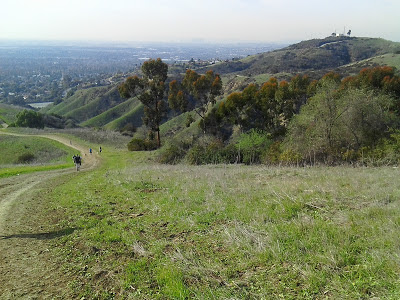
Top of Mariposa Trail, looking West.
As always get out there and have fun and remember to be safe...

Trail map: